 Photo: Misalalic · CC BY-SA 4.0
Slavonia & the Danube
Cross eastern Croatia through Kutjevo, Osijek, Kopački Rit, Vukovar, Ilok and Đakovo over five days.
- Allow
- 5 days
- Route
- 744 km
- Drive time
- 9 hr 18 min
- Stops
- 7
East of Zagreb, Croatia becomes continental and spacious. Kutjevo introduces the wine hills, Osijek brings Habsburg urbanism to the Drava, Kopački Rit opens into floodplain habitat and Vukovar and Ilok place modern history and Danube culture on the same river journey.
This route deserves context and restraint. Book a guide or museum time in Vukovar, use licensed nature excursions in Kopački Rit and appoint a sober driver in Kutjevo and Ilok. The motorway handles distance; the roadbook begins once the villages and rivers take over.
The road, in one glance
Pinch or scroll with Ctrl / ⌘ to zoom
Drawing the route…
The route earns
its distance
Each pin is selected as a place to do something—not merely proof that you passed through.
 Photo: Nick Savchenko from Kiev, Ukraine · CC BY-SA 2.0
Zagreb
Leave east after breakfast and use the motorway to protect time for Slavonia itself.
Zagreb ( ZAH-greb; Croatian: ) is the capital and largest city of Croatia. It is in the north of the country, along the Sava river, at the southern slopes of the Medvednica mountain. Zagreb stands near the international border between Croatia and Slovenia at an elevation of approximately 158 m (518 ft) above sea level.
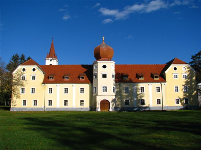 Photo: Dalibor Ribičić · CC BY-SA 4.0
Kutjevo wine country
Vineyards rise beneath the Papuk range around one of Croatia’s historic wine centers.
Kutjevo is a small Slavonian town at the foot of the Krndija hills, surrounded by one of Croatia's long-established wine landscapes. Cellars, vineyards and the historic former abbey estate make the town the practical centre of the surrounding Golden Valley wine country.
 Photo: Roko Poljak · CC BY-SA 4.0
Osijek
The Tvrđa fortress district, Secession architecture and Drava promenade make a relaxed two-night base.
Osijek is the largest city and the economic and cultural hub of the eastern Croatian region of Slavonia, as well as the administrative seat of Osijek-Baranja County. It is the fourth-largest city in Croatia, with a population of 96,313 recorded in the 2021 census. The city is situated on the southern bank of the Drava River, 25 km (16 mi) upstream from its confluence with the Danube, at an elevation of 94 m (308 ft).
Photo: Misalalic · CC BY-SA 4.0Kopački Rit
Danube and Drava floodplains create one of Europe’s important wetland habitats for birds and wildlife.
Kopački Rit is a nature park in eastern Croatia in the municipalities of Bilje and Kneževi Vinogradi. It is located northwest of the confluence of the Drava and the Danube, situated at the border with Serbia. It comprises many backwaters and ponds along the Danube.
 Photo: Bybbisch94, Christian Gebhardt · CC BY-SA 4.0
Vukovar
Danube architecture and carefully interpreted war-memory sites make this an essential, serious stop.
Vukovar is a city in Croatia, in the eastern regions of Syrmia and Slavonia. It contains Croatia's largest river port, located at the confluence of the Vuka and the Danube. Vukovar is the seat of Vukovar-Syrmia County and the second-largest city in the county after Vinkovci.
 Photo: Modzzak · Public domain
Ilok
A hilltop old town and cellars overlook the Danube at Croatia’s eastern edge.
Ilok is Croatia's easternmost town, set on a ridge above the Danube beside the Serbian border. Medieval walls, the Odescalchi castle complex and centuries-old wine cellars make it both a frontier settlement and a centre of the Srijem wine region.
 Photo: Nick Savchenko from Kiev, Ukraine · CC BY-SA 2.0
Đakovo
A twin-spired cathedral and Lipizzaner tradition provide the final cultural stop westbound.
Đakovo is a town in the region of Slavonia, Croatia. Đakovo is the centre of the fertile and rich Đakovo region (Croatian: Đakovština ).
Drive the conditions,
not the itinerary.
Book wetland access and wine visits, keep the driver sober and follow any local border-zone or flood guidance near the Danube.
Checked against
the people who run it
Distances and driving times are planning estimates. Conditions, closures, ferries, permits and park rules can change, so check the linked official guidance before setting out.